top of page
Beyond Agronomy ... fababeans as seen by AgEagle

Flown using a modified 20 MP camera that filters out red wavelengths and adds near infrared light. Produces a reddish image.

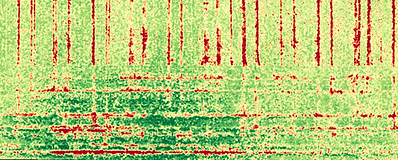
NDVI (normalized difference vegetation index) uses false colours to show differences in crop growth & crop health. Generally, red areas are thin crop or unhealthy crop.
Note seeding errors, compaction, residue issues, healthy crop in low areas where there is water.

Another way of developing the NDVI, with differences in calculations and colour ramps that make things appear a little different.

The AgEagle can also produce detailed digital terrain models of your fields, or it can be used for other surveying work.

See the results of the DJI Inspire

bottom of page